
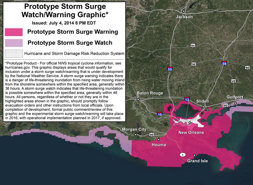
A prototype of the new storm surge warning system developed by NOAA in time for the 2015 hurricane season. Courtesy illustration
Fewer named storms are expected for the 2015 hurricane season, which begins Monday, June 1 and runs through November 30. Also a new prototype storm surge graphic will be used by the National Oceanic and Atmospheric Administration, which released its annual predictions May 27. NOAA will now be able to provide separate watches or warnings for the dangers presented by wind and storm surges.
The prediction calls for a 70 percent likelihood of six to 11 named storms (including Tropical Storm Ana this month). Of those only three to six are expected to become hurricanes, and of those, from zero to two are likely to become major hurricanes. To be ranked a major hurricane, a storm must have have sustained winds from 111 to 129 miles per hour, a Category 3 hurricane on the Saffir-Simpson Hurricane Wind Scale.
“A below-normal season doesn’t mean we’re off the hook,” said Noaa Administrator Kathryn Sullivan, Ph.D. “As we’ve seen before, below-normal seasons can still produce catastrophic impacts to communities.”
The 1992 season serves as a warning example, with only seven named storms forming. The first of those was Hurricane Andrew, a Category 5 hurricane that devastated South Florida.
The main factor leading to low storm predictions is due suppression of instigating winds by El Niño weather pattern. An El Niño is an unusually warm ocean current that develops in late December along the coast of Ecuador and Peru. It can affect weather patterns in the northern hemisphere.
“El Niño is expected to have its greatest influence during the peak months of the season,” said Gerry Bell, Ph.D., lead seasonal hurricane forecaster with NOAA’s Climate Prediction Center. “We also expect sea surface temperatures in the tropical Atlantic to be close to normal, whereas warmer waters would have supported storm development.”
New graphics
NOAA’s National Hurricane Center will use new storm surge watch/warning graphics to highlight areas along the Gulf and Atlantic coasts at risk of life-threatening surges. The new graphics will introduce the concept of a watch or warning specific to the storm. Storm surge is often the most deadly threat to life and property from a tropical storm or hurricane.
Having separate warnings for these two hazards should provide emergency managers, the media and the general public better guidance on the hazards they face when tropical cyclones threaten, NOAA announced in a press release.
May 24-30 has been set aside as National Hurricane Preparedness Week. Tips, along with video and audio public services announcements can be found at www.hurricanes.gov/prepare.
"It only takes one hurricane or tropical storm making landfall in your community to significantly disrupt your life,” said FEMA Deputy Administrator Joseph Nimmich. “Everyone should take action now to prepare themselves and their families for hurricanes and powerful storms. Develop a family communications plan, build an emergency supply kit for your home, and take time to learn evacuation routes for your area. Knowing what to do ahead of time can literally save your life and help you bounce back stronger and faster should disaster strike in your area."