
National Weather Service map of Tropical Storm Harvey, which is expected to upgrade to a Category 1 hurricane by the time it hits landfall Friday evening, August 26. Map courtesy National Weather Service
10 a.m. Thursday, August 24
Hurricane Harvey could be a Category 3 hurricane by the time it makes landfill sometime Friday afternoon or evening, according to the latest news from the National Weather Service.
A category 3, with sustained winds between 111-129 mph, is considered a major hurricane.
All RVs have been ordered to leave Mustang and Padre islands by no later than 6 p.m. today, announced the Texas Department of Transportation. Two ferries on TX 361 are now dedicated to transporting RVs out of Port Aransas.
8 a.m. Thursday, August 24
The Texas Coast is officially under a hurricane warning, upgraded from a hurricane watch issued yesterday. The tropical depression heading for the coast has been upgraded to a tropical storm and is expected to become Hurricane Harvey by the time it hits land Friday evening, August 25.
Now blowing at 45 miles per hour, the storm could bring winds as high as 110 mph, depending on whether it is a Category 1 (74-95 mph) or Category 2 hurricane (96-110 mph). Tropical storm winds of 39-73 mph could begin in Corpus Christi by mid-day Friday.
The majority of South Texas has been placed under a flash food watch. In fact, experts believe water will deliver more destruction than the wind in the 30 counties in its path. Governor Greg Abbott has already declared a disaster designation for these counties, including Nueces County, ahead of the flooding.
The biggest danger comes from the storm’s slow movement. Over the Gulf it is moving at 10 mph, but will most likely stall over land, bringing massive amounts of rain up to 25-30 inches and storm surges between 4-6 feet.
Coastal Bend residents should brace for the strongest possible storm predicted said National Weather Service officials.
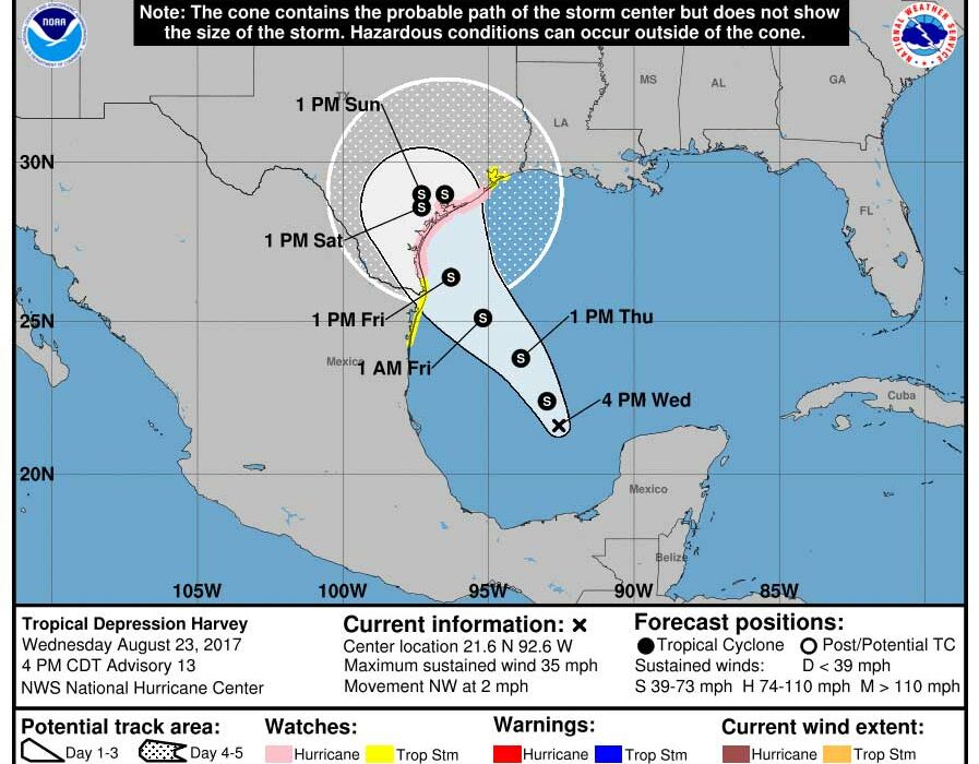
3 p.m.Wednesday, August 23
A tropical storm is expected to become Hurricane Harvey when it makes landfall in the Coastal Bend sometime on the night of Friday, Aug. 25. It could possible intensify to a Category 2, according to the National Weather Service.
Currently at 35 mph, Harvey is gaining strength as it moves over the warm waters of the Gulf of Mexico, heading straight for the central Gulf area. Emergency management organizations in Corpus Christi and surrounding areas are gearing up for a major rain event and should be fully activated by Thursday. The storm is expected to hit full force by Friday morning.
A hurricane watch has been issued for coastal areas, along with a storm surge warning. Rainfall is expected at 6-12 inches, with 20 inches possible. Flash flooding is also possible.
Peak storm surge flooding is estimated to crest at 4-6 feet above ground level. The storm may also stall over land for the entire weekend.
Texas A&M University-Corpus Christi ordered a mandatory evacuation of their Island Campus beginning Thursday, Aug. 24, while the Art Center of Corpus Christi has asked artists to remove their artwork by the end of the farmers market on Wednesday, Aug. 23. Art work is not insured, and the Art Center might be closed the rest of the week. The market ends at 8 p.m. Wednesday.
Local stores are stocking up on bottled water and batteries, which are selling out almost as quickly as they are put on the shelves.