
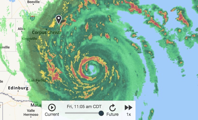
Progress of Hurricane Harvey at 11:02 a.m. Friday, August 25, according to National Weather Service mapping tools. Water is already up to the steps of the seawall on Padre Island and the bottom of the signs at beach entrances.
10 a.m. Friday, August 25
Hurricane Harvey is not expected to move out of the Coastal Bend region until Tuesday, August 29, according the National Weather Service. Area residents will need to be somewhere safe by around mid-day today, Friday, August 25. Strong winds and heavy rain are expected at sundown, reaching Category 3 strength at up to 120 miles per hour. Storm surges are expected from 6-12 feet.
Water will mostly likely deliver the most damage as the storm is expected to stall over land. Rainfall up to 20 inches is expected over the next three days. Flash flood warnings are expected throughout the region by Saturday morning and could continue through Monday.
Currently, it is 76 degrees F in Corpus Christi. Wind speeds are up to 35 mph.
All flights out of Corpus Christi International Airport have been cancelled until Monday.
Stayed tuned for updates, including reports on a noon press conference at city hall.